No pics again.
Dog Valley/Peavine
Moderator: hemingray
Dog Valley/Peavine
We went up to our spot again this weekend. For something different, we ventured up Dog Valley and crossed into Nevada. From there we headed up to Peavine and surrounding peaks. Beautiful day, had lunch and then headed back to camp. Riding thru DV was hot, as was camping. But, since Stampede is so high this year, it's a 5 minute jaunt to go jump in the lake. Great way to cool down after a long ride. Water is probably about 72 or so. I do recommend some kind of aqua sock or something though, barefoot wasn't cuttin it for me. The rocks on the lake bottom are KILLER on the feet!
No pics again.
No pics again.
'15 Can Am Maverick XRS DPS

Re: Dog Valley/Peavine
Bad Kendo! We need to see how the flowers and the bees look over that way!Kendo wrote:No pics again.
Been wondering about riding over to Peavine - something I read somewhere had lots of gates and angry landowners near there, maybe on the 395 side?
For walking in lake and creekbottoms I like those water sport sandals. I have a pair that have survived lakes, rivers, Hawaii and they're so easy to pack.
Wherever I go, there I am
Paynes Creek 2016!
~~~~~~~~~~~~~~~~~~
16 Yamaha Wolverine R-Spec EPS SE
09 Yamaha Grizzly 700 FI 4x4 EPS
Paynes Creek 2016!
~~~~~~~~~~~~~~~~~~
16 Yamaha Wolverine R-Spec EPS SE
09 Yamaha Grizzly 700 FI 4x4 EPS
Re: Dog Valley/Peavine
Yeah, I know, I suck.
We had no trouble going in from the CA side. I can give you a GPX file that shows exactly how to get there from the Henness Pass/Stampede intersection. Only thing we ran into was some firewood cutters on one of the trails. No biggie. Easy ride too, the road up to Peavine is a bit rocky and will beat on you a little, but it's doable.
We had no trouble going in from the CA side. I can give you a GPX file that shows exactly how to get there from the Henness Pass/Stampede intersection. Only thing we ran into was some firewood cutters on one of the trails. No biggie. Easy ride too, the road up to Peavine is a bit rocky and will beat on you a little, but it's doable.
'15 Can Am Maverick XRS DPS
Re: Dog Valley/Peavine
REALLY SUCK.
I think Eric and I did some of that...on our jaunt from Stampede to Moonrocks. Eric could confirm.
I think Eric and I did some of that...on our jaunt from Stampede to Moonrocks. Eric could confirm.
The last words spoken before a YouTube video is filmed: "Hold my beer, now watch this..."
Regards,
Ken Hower
RTF Director
http://www.rubicontrail.org/
Regards,
Ken Hower
RTF Director
http://www.rubicontrail.org/

Re: Dog Valley/Peavine
dang kendo no pics!!! go to here your getting out! 
South Side Keeper
Paynes Creek 2017
Paynes Creek 2017
-
GrizzlyGuy

- Forever On The trail - RIP
- Posts: 1411
- Joined: Sun Jul 08, 2007 6:11 pm
- Location: Truckee, CA
- Contact:
Re: Dog Valley/Peavine
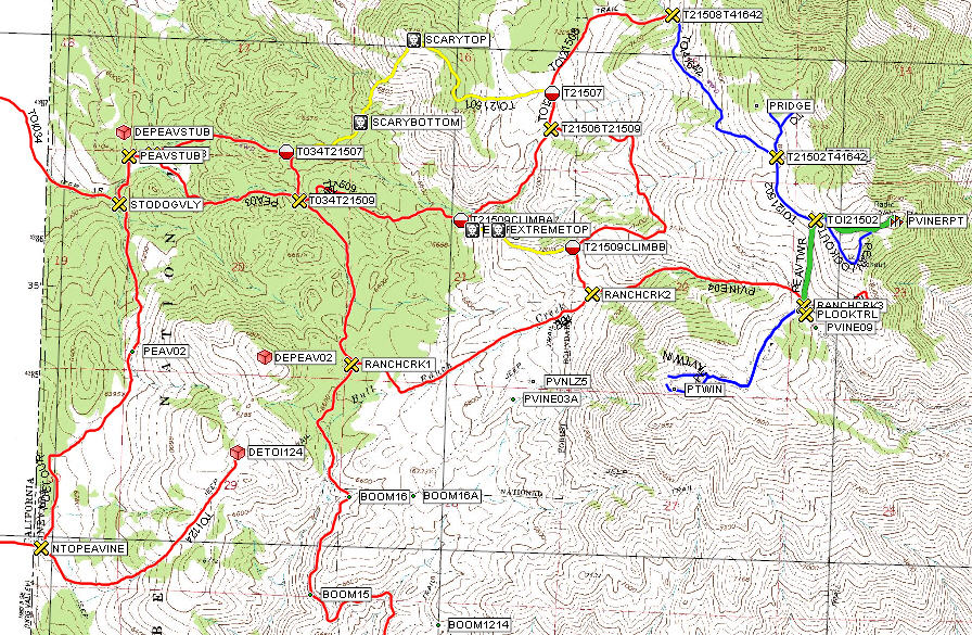
I've got it pretty well mapped out after riding up there several times, you can get there from Boca and save yourself the drive down to 395. My maps will even let you avoid these angry land owners:hemingray wrote:Been wondering about riding over to Peavine - something I read somewhere had lots of gates and angry landowners near there, maybe on the 395 side?


Here is part of my map, over here I talked about sliding down one of those trails basically out of control:
Yes we did! We even got to ride one of the motorcycle trails when I took that wrong turn.Ken wrote:I think Eric and I did some of that...on our jaunt from Stampede to Moonrocks. Eric could confirm.
Since Kendo was lame and forgot to post pictures (


TV For Thrill Seekers: http://AdventureWorld.TV
More Videos: http://GrizzlyGuy.TV
Some More Videos: http://www.youtube.com/user/ATVGrizzlyGuy
Photos: http://www.GrizzlyGuy.com/ATVs
My quad: Grizzly 700, 25" Bighorns, Bash Plates,
Warn 2500 Winch
More Videos: http://GrizzlyGuy.TV
Some More Videos: http://www.youtube.com/user/ATVGrizzlyGuy
Photos: http://www.GrizzlyGuy.com/ATVs
My quad: Grizzly 700, 25" Bighorns, Bash Plates,
Warn 2500 Winch
Re: Dog Valley/Peavine
So hey GG, I've been trying to connect the 19 road to the 45 road (Monumental Creek). Got some tracks and pics? That way I can stop looking and won't have to take pictures!! 
Wherever I go, there I am
Paynes Creek 2016!
~~~~~~~~~~~~~~~~~~
16 Yamaha Wolverine R-Spec EPS SE
09 Yamaha Grizzly 700 FI 4x4 EPS
Paynes Creek 2016!
~~~~~~~~~~~~~~~~~~
16 Yamaha Wolverine R-Spec EPS SE
09 Yamaha Grizzly 700 FI 4x4 EPS
Re: Dog Valley/Peavine
So when we went this time, I took 124 across to the big intersection with 668 and 509 coming in. We took 506 from there and connected with Peavine Rd. Coming back down we hit 509 and 668. I made a track file I just haven't done anything with it yet. I don't think I've been on the 34 road further north, maybe I'll do that one next time. That area is just littered with trails and offshoots. You can ride for a couple of days up there easily.
Funny, I don't recall anything "extreme" in my riding. Then again, I never did a reverse wheelie on the Goat Trail to Signal Peak either. Nor have I had my ass in the air on the Bear Valley Loop. LMAO
Funny, I don't recall anything "extreme" in my riding. Then again, I never did a reverse wheelie on the Goat Trail to Signal Peak either. Nor have I had my ass in the air on the Bear Valley Loop. LMAO
'15 Can Am Maverick XRS DPS
-
GrizzlyGuy
- Forever On The trail - RIP
- Posts: 1411
- Joined: Sun Jul 08, 2007 6:11 pm
- Location: Truckee, CA
- Contact:
Re: Dog Valley/Peavine
The "extreme" waypoints on my map are for that really steep section that is a lot of fun and not bad going UP (gas on all the way), but would be a real beach to ride down. I think Ken and I went up it on our way through there. I like to mark those so that I don't oopsie-diddle and ride it the wrong way. I guess you could try walking the quad down, but then you'd end up running over your foot, and...Kendo wrote:Funny, I don't recall anything "extreme" in my riding. Then again, I never did a reverse wheelie on the Goat Trail to Signal Peak either. Nor have I had my ass in the air on the Bear Valley Loop. LMAO
No problem, but you'll have to trade the Grizzly in on a talented and fearless Mule.hemingray wrote:So hey GG, I've been trying to connect the 19 road to the 45 road (Monumental Creek). Got some tracks and pics? That way I can stop looking and won't have to take pictures!!
TV For Thrill Seekers: http://AdventureWorld.TV
More Videos: http://GrizzlyGuy.TV
Some More Videos: http://www.youtube.com/user/ATVGrizzlyGuy
Photos: http://www.GrizzlyGuy.com/ATVs
My quad: Grizzly 700, 25" Bighorns, Bash Plates,
Warn 2500 Winch
More Videos: http://GrizzlyGuy.TV
Some More Videos: http://www.youtube.com/user/ATVGrizzlyGuy
Photos: http://www.GrizzlyGuy.com/ATVs
My quad: Grizzly 700, 25" Bighorns, Bash Plates,
Warn 2500 Winch
Re: Dog Valley/Peavine
Hey, that was only once and it was uphill. So there!!GrizzlyGuy wrote:...I guess you could try walking the quad down, but then you'd end up running over your foot, and...
'15 Can Am Maverick XRS DPS
Who is online
Users browsing this forum: No registered users and 64 guests